 |

|
|
Empire Deluxe Internet Edition Beta Screens
Terrain Sheets
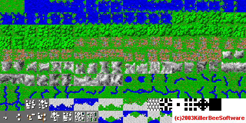
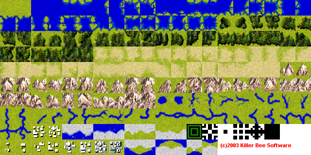
Terrain Sheet Specs Also, the sheet must have 20 icons per row, with the icons contiguous in each row, and each row contiguous with the other rows. Everything starts at the origin of the bitmap. The icons must be placed be in the following order:
----ROW 1----
 Clear #1
 Clear #2
 Sea #1
 Sea #2
 Coast #1 with land to the North
 Coast #2 with land to the North
 Coast #1 with land to the East
 Coast #2 with land to the East
 Coast #1 with land to the North, East
 Coast #2 with land to the North, East
 Coast #1 with land to the South
 Coast #2 with land to the South
 Coast #1 with land to the North, South
 Coast #2 with land to the North, South
 Coast #1 with land to the East, South
 Coast #2 with land to the East, South
 Coast #1 with land to the North, East, South
 Coast #2 with land to the North, East, South
 Coast #1 with land to the West
 Coast #2 with land to the West

 ----Row 2----
 Coast #1 with land to the North, West
 Coast #2 with land to the North, West
 Coast #1 with land to the East, West
 Coast #2 with land to the East, West
 Coast #1 with land to the North, East, West
 Coast #2 with land to the North, East, West
 Coast #1 with land to the South, West
 Coast #2 with land to the South, West
 Coast #1 with land to the North, South, West
 Coast #2 with land to the North, South, West
 Coast #1 with land to the East, South, West
 Coast #2 with land to the East, South, West
 Coast #1 with land to the North, East, South, West
 Coast #2 with land to the North, East, South, West
 Forest #1
 Forest #2
 Forest #1 with Forest to the North
 Forest #2 with Forest to the North
 Forest #1 with Forest to the East
 Forest #2 with Forest to the East

 ----Row 3----
 Forest #1 with Forest to the North, East
 Forest #2 with Forest to the North, East
 Forest #1 with Forest to the South
 Forest #2 with Forest to the South
 Forest #1 with Forest to the North, South
 Forest #2 with Forest to the North, South
 Forest #1 with Forest to the East, South
 Forest #2 with Forest to the East, South
 Forest #1 with Forest to the North, East, South
 Forest #2 with Forest to the North, East, South
 Forest #1 with Forest to the West
 Forest #2 with Forest to the West
 Forest #1 with Forest to the North, West
 Forest #2 with Forest to the North, West
 Forest #1 with Forest to the East, West
 Forest #2 with Forest to the East, West
 Forest #1 with Forest to the North, East, West
 Forest #2 with Forest to the North, East, West
 Forest #1 with Forest to the South, West
 Forest #2 with Forest to the South, West

 ----Row #4----
 Forest #1 with Forest to the North, South, West
 Forest #2 with Forest to the North, South, West
 Forest #1 with Forest to the East, South, West
 Forest #2 with Forest to the East, South, West
 Forest #1 with Forest to the North, East, South, West
 Forest #2 with Forest to the North, East, South, West
 Rough #1
 Rough #2
 Rough #1 with Rough to the North
 Rough #2 with Rough to the North
 Rough #1 with Rough to the East
 Rough #2 with Rough to the East
 Rough #1 with Rough to the North, East
 Rough #2 with Rough to the North, East
 Rough #1 with Rough to the South
 Rough #2 with Rough to the South
 Rough #1 with Rough to the North, South
 Rough #2 with Rough to the North, South
 Rough #1 with Rough to the East, South
 Rough #2 with Rough to the East, South

 ----Row 5----
 Rough #1 with Rough to the North, East, South
 Rough #2 with Rough to the North, East, South
 Rough #1 with Rough to the West
 Rough #2 with Rough to the West
 Rough #1 with Rough to the North, West
 Rough #2 with Rough to the North, West
 Rough #1 with Rough to the East, West
 Rough #2 with Rough to the East, West
 Rough #1 with Rough to the North, East, West
 Rough #2 with Rough to the North, East, West
 Rough #1 with Rough to the South, West
 Rough #2 with Rough to the South, West
 Rough #1 with Rough to the North, South, West
 Rough #2 with Rough to the North, South, West
 Rough #1 with Rough to the East, South, West
 Rough #2 with Rough to the East, South, West
 Rough #1 with Rough to the North, East, South, West
 Rough #2 with Rough to the North, East, South, West
 Mountain #1
 Mountain #2

 ----Row 6----
 Mountain #1 with Mountain to the North
 Mountain #2 with Mountain to the North
 Mountain #1 with Mountain to the East
 Mountain #2 with Mountain to the East
 Mountain #1 with Mountain to the North, East
 Mountain #2 with Mountain to the North, East
 Mountain #1 with Mountain to the South
 Mountain #2 with Mountain to the South
 Mountain #1 with Mountain to the North, South
 Mountain #2 with Mountain to the North, South
 Mountain #1 with Mountain to the East, South
 Mountain #2 with Mountain to the East, South
 Mountain #1 with Mountain to the North, East, South
 Mountain #2 with Mountain to the North, East, South
 Mountain #1 with Mountain to the West
 Mountain #2 with Mountain to the West
 Mountain #1 with Mountain to the North, West
 Mountain #2 with Mountain to the North, West
 Mountain #1 with Mountain to the East, West
 Mountain #2 with Mountain to the East, West

 ----Row 7----
 Mountain #1 with Mountain to the North, East, West
 Mountain #2 with Mountain to the North, East, West
 Mountain #1 with Mountain to the South, West
 Mountain #2 with Mountain to the South, West
 Mountain #1 with Mountain to the North, South, West
 Mountain #2 with Mountain to the North, South, West
 Mountain #1 with Mountain to the East, South, West
 Mountain #2 with Mountain to the East, South, West
 Mountain #1 with Mountain to the North, East, South, West
 Mountain #2 with Mountain to the North, East, South, West
 Lake #1
 Lake #2
 River #1 with river or coast to the North
 River #2 with river or coast to the North
 River #1 with river or coast to the East
 River #2 with river or coast to the East
 River #1 with river or coast to the North, East
 River #2 with river or coast to the North, East
 River #1 with river or coast to the South
 River #2 with river or coast to the South

 ----Row 8----
 River #1 with river or coast to the North, South
 River #2 with river or coast to the North, South
 River #1 with river or coast to the East, South
 River #2 with river or coast to the East, South
 River #1 with river or coast to the North, East, South
 River #2 with river or coast to the North, East, South
 River #1 with river or coast to the West
 River #2 with river or coast to the West
 River #1 with river or coast to the North, West
 River #2 with river or coast to the North, West
 River #1 with river or coast to the East, West
 River #2 with river or coast to the East, West
 River #1 with river or coast to the North, East, West
 River #2 with river or coast to the North, East, West
 River #1 with river or coast to the South, West
 River #2 with river or coast to the South, West
 River #1 with river or coast to the North, South, West
 River #2 with river or coast to the North, South, West
 River #1 with river or coast to the East, South, West
 River #2 with river or coast to the East, South, West

 ----Row 9----
 River #1 with river or coast to the North, East, South, West
 River #2 with river or coast to the North, East, South, West
 City #1 (old style, not used)
 City #2 (old style, not used)
 Northern icecap with sea to the south #1
 Northern icecap with sea to the south #2
 Southern icecap with sea to the north #1
 Southern icecap with sea to the north #2
 Northern icecap with land to the south #1
 Northern icecap with land to the south #2
 Southern icecap with land to the north #1
 Southern icecap with land to the north #2
 Map edge
 Survey cursor
 Button for editor (single draw)
 Button for editor (multi draw)
 Alternate cursor
 Unexplored blit
 (not used)
 (not used)

 ----Row 10----
 Neutral City Icon Level #1
 Neutral City Icon Level #2
 Neutral City Icon Level #3
 Neutral City Icon Level #4
 Neutral City Icon Level #5
 Neutral City Icon Level #6
 Neutral City Icon Level #7
 Neutral City Icon Level #8
 North Wrap border with sea to West, land to East
 North Wrap border with sea to East, land to west
 South Wrap border with sea to West, land to East
 South Wrap border with sea to East, land to west
 North Wrap border with land to East and West
 South Wrap border with land to East and West
 Remaining squares unused

---END---
Unit Icon Sheets
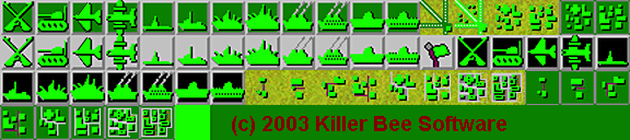 The unit icon sheets can be of any size. However, each unit icon must be square, and they all have to have the same side length. The side length is specified when the user configures the INI file for that sheet. Also, in the INI file, there is one entry per player position, so you can have different sized icon sheets in different positions. The sheet must have 18 icons per row, with the icons contiguous in each row, and each row contiguous with the other rows. Everything starts at the origin of the bitmap. The icons must be placed be in the following order:
----Row 1----
Infantry
Armor
Fighter
Bomber
Sub
Destroyer
Cruiser
Battleship
Transport
Transport_Loaded
Carrier
Carrier_Loaded
Airbase
Airbase_Loaded
City 1		(old style, not used)
City 2		(old style, not used)
City 1 Loaded	(old style, not used)
City 2 Loaded	(old style, not used)

----Row 2----
Infantry Sentry
Armor Sentry
Fighter Sentry(sic)
Bomber Sentry(sic)
sub Sentry
Destroyer Sentry
Cruiser Sentry
Battleship Sentry
Transport Sentry
Transport_Loaded Sentry
Carrier Sentry
Carrier_Loaded Sentry
Icon Set Army Symbol
Infantry Old
Armor Old
Fighter Old
Bomber Old
Sub Old

----Row 3----
Destroyer Old
Cruiser Old
Battleship Old
Transport Old
Transport_Loaded Old (sic)
Carrier Old
Carrier_Loaded Old (sic)
City Icon Level #1 Not Loaded
City Icon Level #2 Not Loaded
City Icon Level #3 Not Loaded
City Icon Level #4 Not Loaded
City Icon Level #5 Not Loaded
City Icon Level #6 Not Loaded
City Icon Level #7 Not Loaded
City Icon Level #8 Not Loaded
City Icon Level #1 Loaded
City Icon Level #2 Loaded
City Icon Level #3 Loaded

----Row 4----
City Icon Level #4 Loaded
City Icon Level #5 Loaded
City Icon Level #6 Loaded
City Icon Level #7 Loaded
City Icon Level #8 Loaded
Rest is unused
Those I noted with (sic) are never used in the game, just taking up space to keep things ordered correctly.
Overlays
 The Overlays are used to clean up the unexplored areas, and show battle explosions. There is a TRANSPARENT COLOR that you speciy in the INI file. On this sheet, the transparent color is white (rgb 255,255,255) The overlay sheet can be of any size. However, each overlay icon must be square, and they all have to have the same side length. The side length is specified when the user configures the INI file for that sheet. Also, the sheet must have 15 icons per row, with the icons contiguous in each row, and each row contiguous with the other rows. Everything starts at the origin of the bitmap. ----Row 1---- Unexplored edge overblit - North Unexplored edge overblit - East Unexplored edge overblit - North, East Unexplored edge overblit - South Unexplored edge overblit - North, South Unexplored edge overblit - East, South Unexplored edge overblit - North, East, South Unexplored edge overblit - West Unexplored edge overblit - North, West Unexplored edge overblit - East, West Unexplored edge overblit - North, East, West Unexplored edge overblit - South, West Unexplored edge overblit - North, South, West Unexplored edge overblit - East, South, West Unexplored edge overblit - North, East, South, West ----Row 2---- Explosion Anim 1 Explosion Anim 2 Explosion Anim 3 Explosion Anim 4 Explosion Anim 5 Explosion Anim 6 You will observe there are some squares that are not used in all of these sheets, but their position must be maintained..
© 2018 Killer Bee Software
|